A blog for better streets and public spaces in Portland, Maine.

Monday, June 18, 2007

Parking is for Losers.

Nothing kills a downtown like cheap and abundant parking. This, essentially, is the conclusion of Philadelphia Federal Reserve Bank economist Richard Voith in this 1998 research paper.

Downtowns, or Central Business Districts (CBDs), are increasingly competing with suburban office complexes and subdivisions. Theoretically, each has its own niche: the burbs offer cheap and abundant parking, but you'll die at an early age from the sedentary lifestyle and all the crap you'll eat from lousy franchise restaurants. CBDs, on the other hand, offer cultural events, good restaurants, and pleasant, walkable neighborhoods, but parking is difficult and expensive.

The suburbs seldom try to compete with the CBD by tearing out a parking lot and building a performance arts venue or a celebrity chef's restaurant. But for some reason, CBDs frequently try to compete with the 'burbs by subsidizing cheap parking at the expense of their vibrant communities and neighborhoods.

Voith offers cities two choices, depending on the competitive position of a downtown area: if your office workers and households couldn't care less about your central city and its amenities, then by all means, tear it all down and build cheap parking. Voith admits that "this approach is unlikely to dramatically improve a downtown’s competitive position because the suburbs have a comparative advantage in land uses that demand a lot of space, such as parking lots and roads." Detroit is probably the largest city to have followed this self-destructive model.

"Alternatively, if enough people and firms still find that the dense development found in CBDs is as valuable as ever, adopting policies to increase parking is likely to be counterproductive. Rather, policies should seek to provide high-quality alternatives to driving and parking while accommodating those potential visitors and commuters who must drive, but at prices reflective of both the high value of CBD land and the costs of increased congestion associated with cars in the CBD. Basically, this means improving transit access to the CBD by broadening markets served and improving the price and quality of transit...

Regardless of which view of the value of CBD agglomerations one subscribes to, increasing the parking supply is not a panacea for CBDs. In fact, parking prices in highly successful CBDs are bound to be high relative to those of other competing economic centers. Low parking prices in the CBD are more likely to reflect the failure of the CBD to maintain its unique position as a regional center than to reflect successful parking policies." (Voith, 1998)

In other words, cheap, subsidized parking is a dangerous drug of last resort for failing downtowns.

On a related note, the Wall Street Journal reports that mass transit stations have a strong positive influence on neighborhood property values, and "transit-oriented development" is gaining favor among developers and real estate investors. Read it soon before it goes into the pay archives.

Monday, June 11, 2007

I We Love This Building

UPDATE 6/13: Portland voters rejected the proposal to move the Library by a comfortable 56% to 44% margin. Thanks to all of you who voted or provided free publicity to our scrappy opposition campaign.

Portlanders have a reputation for architectural conservatism: it's a rare building that goes up downtown without a faux-historical coating of red brick. I suspect that this is one reason that the central library's brash modernist architecture doesn't receive the respect it deserves.


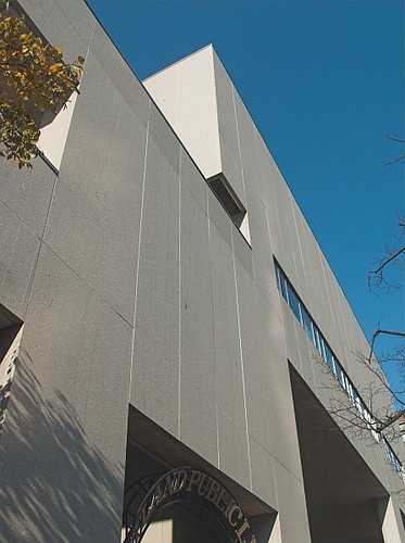
But I love this building. The gravity-defying front entrance (above) creates a quiet, shady courtyard that both expands the public space of Monument Square and provides a calming refuge from the bustle of the city center.

Inside, a skylit ramp leads to the circulation desk and the amply daylighted collections of new books and current magazines. Keep in mind that while this building may have been built before the "green" architecture fad, it was built during a serious energy crisis, and the architecture responds with ample daylight and elements of passive solar design.

I'm especially fond of the side of the building along Elm Street. Metro riders are familiar with this facade and the thoughtful clock that complements the bus schedules posted at the Elm Street transit center. The building mirrors the climbing topography of the street, and a series of one-story "steps" makes the transition from the low-rise neighborhood around Cumberland Avenue to the monumental architecture of Monument Square in the space of one block. From the sidewalk, the long, low main level looks like a delicate counterweight that balances the jumble of higher stories massed near Monument Square:


To be sure, the interior of the Library needs to be updated: how we use libraries has changed dramatically since this building opened in 1979. But the overall structure of the building continues to serve the Library's public education mission remarkably well in spite of its age, and I believe that the generous interactions between the public library and the public square in front of it are a tremendous credit to the building's success.

Now, the old public market building is also nice. But it wasn't designed to be a library: in order to fit in the necessary stacks, desks, and office space, the library's trustees plan to block views of the dramatic post-and-beam ceiling with a second floor in between the ground level and the roof. The renovated market would lose much of its architectural appeal, and at 3/4 the size of the current library, it's going to be cramped to boot.

On a more pragmatic note, the relocation plan would spend millions of dollars in public and private foundation money that would be better spent on things like books, computers, librarians, and educational programs.

The election that will determine this building's fate will be held tomorrow. Vote, please. And if you don't live in Portland, Maine, come and visit our awesome library sometime.

Look at more photos of our library here.

Thursday, June 7, 2007

Love This Place.

One of the characteristics that makes Portland such a walkable city is how its greatest public buildings are framed at the end of our streets: look up Temple Street, and there's the stately Unitarian Church. Winding along Fore Street, the streetscape suddenly opens up at Boothby Square to frame the old Custom House. And at the top end of the former Middle Street, we have this, our Public Library, bookending the great public square in the heart of downtown Portland.

Seeing buildings at the end of streets makes our city feel smaller and adds to our street life: if you can see it, you can walk there, and most people do. So all the better if the architectural artwork that our streets frame happens to be a public building like a church or a library. Who wants to stroll down a street that dead-ends at a monstrous concrete parking garage?


This photo comes courtesy of selfnoise, who has many excellent pictures of Portland on his flickr page.
When I was a kid, this building was usually the destination when my family came to visit downtown Portland from Steep Falls, Maine. The building and its surroundings - the Square, the old gothic skyscapers next door - made Portland seem more exciting than it actually was in an era when several Congress Street buildings had been abandoned. When it was built in 1979, downtown Portland was losing its life to the Maine Mall, but the Library gave families like mine a reason to come downtown again. It was, and still is, a great public building that enjoys a mutually beneficial relationship with a great public space, Monument Square.

It saddens me that the Library's trustees are in such a rush to sell this public space short, to abandon a great building to move into a smaller space around the corner, in the shadow of Bayside's white elephant parking garage.

Luckily, it's not a done deal yet. Portland voters will have a chance to save the Library on June 12, during a special election to decide on a bond that would finance the move. We can preserve the library and save a million bucks. Let's all turn out to the polls next Tuesday and vote no on question one.

Wednesday, May 30, 2007

They Bulldozed It


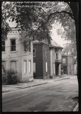
Above: Franklin and Oxford Streets in the 1950s. The other historic photo (below) shows another stretch of the long-lost Franklin Street (historic photographs courtesy of Maine Memory Network)
This photograph here is what the corner of Franklin and Oxford Streets looked like about 50 years ago, before the WASPs on the City Council noticed the Irish name on the corner store, called it a "slum," and bulldozed it all to create the hated Franklin Arterial.

Below, another photograph from the same site of another spot on the former Franklin Street. It's hard to know exactly where, since the buildings, shady elm trees, and even the sidewalks have been gone for decades. For those readers who have never been to Portland, here's what urban renewal gave us instead: a grass median full of garbage, some scrubby trees growing over the old neighborhood's rubble, and four lanes of traffic unencumbered by crosswalks or sidewalks. Here's a photo (the Franklin Towers, Portland's tallest building and a fine example of Soviet Sentimental architecture, commands a fine view of the no-man's-land):


Note how all of these "slum dwellings" in the old photos bear striking resemblance to historic homes that now sell for over $1 million in surrounding neighborhoods. Way to invest in real estate, you jingoist highway-engineering dipshits.

Here's some good news, though: my new buddy Patrick writes about schemes to repair past urban renewal idiocy with a new Franklin Boulevard in the Bollard this week: read about it here. Tomorrow at the Franklin Towers will be a "revisioning workshop" to brainstorm new ideas for the blighted pavement - perhaps I'll see you there. Finally, here's a previous post about fixing Franklin Arterial.

Sunday, May 20, 2007

Sane Ideas for the Adams School

A couple of weekends ago I climbed to the top of the Munj to attend a community charrette for the future of the Adams school and the two blocks of East End neighborhood it occupies.

Billed as a workshop for "crazy ideas," the event was intended to guide the neighborhood association towards a set of goals and guidelines for a forthcoming Request for Proposals for the future development of the site. The ideas turned out to be not so crazy, for the most part - at least, no one proposed a space port or anything like that. More often, people struggled with the tradeoffs of more quotidian desires for a neighborhood with scarce land: Would the neighborhood like to see more housing or more parking? More retail space or more grassy lawns?

We split up into three groups, each of which was guided by some Muskie School planning students and an architect or two to put our ideas on paper. We began by ranking our priorities for the neighborhood: family housing came up most strongly, but so did environmental sustainability and open space.

The conflict between these values struck me early on. Every additional quarter acre dedicated to "open space" means one to three families who won't be able to live in the East End (and they'll likely move to the hinterlands of Scarborough or Standish instead - certainly less than a "sustainable" outcome). Besides, the Eastern Prom, one of Portland's biggest open spaces, is just a short walk away from the school in two directions.

But we also discussed how the East End's plentiful open space is actually used. As it turns out, a lot of it isn't very functional: the majority of it is just a pretty frame for views of the ocean or (in the case of the park on North Street) of the White Mountains. A lot of East Enders use their grassy "open space" primarily as a toilet for their pets, if at all. Even if that is a valid priority, people generally agreed that it shouldn't outrank the need for in-town housing.

But the Adams School's existing playground isn't just a grassy lawn (although the site does have one, and again, it's a dog toilet). It's also an active playground and basketball court that's still well-used even two years after the school's closure. This, it turned out, was what the neighbors in my group really valued: not an empty field faking pastoralism in the middle of the city, but a busy, public square where kids could play and neighbors could meet.

So this is what we came up with:


Triple-decker rowhouses (purple) front Vesper and Munjoy and a new pedestrian court between Beckett and O'Brien Streets. A sun-facing playground and plaza (orange-ish, with green trees) open up along the southern end of the pedestrian connection along Wilson Street, and facing the plaza are storefronts for local non-profits (in blue), topped by additional housing. Two alleys (also orange) through the site access flexible storage space (pink) that can be used as parking or as studio space, at the owner's discretion.

Nan Cumming, who attended as a neighbor but also happens to be the executive director of Portland Trails, advocated early on for connecting O'Brien and Beckett Streets as a pedestrian thoroughfare. Also, our group considered reusing the school, but ultimately rejected the idea in order to make the most of the real estate, recycle the old building's materials, and build new, efficient buildings instead. A sub-group discussed possible ownership models for the housing and concluded that the project should sell affordable, deed-restricted condos built for and marketed to young families.

Then we went to present these ideas to the other groups and hear about their own "crazy" (but not really) ideas. As it turned out, the other groups seemed to hold similar values: housing was definitely the most prominent element of every plan, as was a small playground or garden on the southern end of the site. The other two plans proposed reusing the existing Adams School building for "community" uses or as business incubators, but they also suggested hollowing out the middle portion of the building to provide the same pedestrian connection our group had proposed. No one wanted big parking lots (speaking of which, I wonder if anyone from Ocean Properties is reading this blog yet).

This site plan came from the same group that created the lovely adaptive-reuse drawing above. They've got housing on the north side of the site, along Munjoy, and above commercial uses on Wilson, plus an urban square in the middle and a garden to the south. The school building is would be reused for "community" uses, although I'm not sure how "community" uses would fill all that space and I can't recall the details of their presentation. They proposed adding a sort of pedestrian arcade through the building (see drawing above).

The final group had the prettiest drawings (in my opinion) and the most urban site plan:


They proposed four-story townhouses (top left drawing) along Wilson, Munjoy, and Vesper Streets, and a rehabbed school building with new additions for retail and business incubator space. I thought that their drawing of the reused school was particularly awesome (at right): a sort of warehouse/treehouse perches on top of the old school building with wind turbines.

However, all of the good-looking density that comes with this plan comes at a price: they proposed underground parking, which costs a lot more than surface-level lots or garages. While underground parking looks better, it would probably make the housing here prohibitively expensive for most people.

Now that the conceptual designs are in, the School Reuse Committee will consider the options in its final report to City Council, which will probably put out a Request for Proposals or a Request for Qualifications sometime soon.